

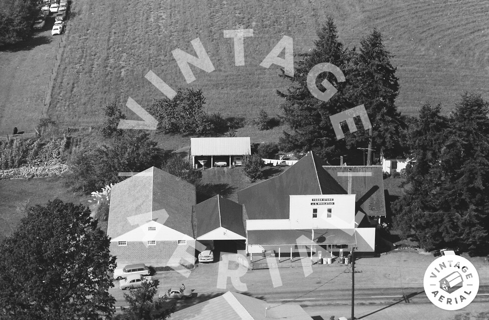
Here’s this week’s Mystery Monday photo! If you like old cars as much as I do, this picture is especially exciting!
Also, we don’t know this photo’s exact location yet. We have a good idea of its general location, but we haven’t been able to track down an address. Needless to say, this will put your research skills to the test!
Lastly, after reading our guidelines below, leave your observations as to what this photo could be and where it might fall on the map. The more descriptions and observations, the better!
Here are the guidelines:
- If you can correctly identify the photo with a link to Google Maps showing where it is, or should be*, you win! Leave a comment here on the blog or on our Facebook Page.
- Whoever identifies the photograph and posts a link to its correct location first wins!
- This week’s winner will receive a $50 coupon for any framed print, or simple bragging rights! Whichever you prefer!
If you know of anyone else who would enjoy this blog (or perhaps someone who would be a great competitor,) please send them here!
Let the games begin!
Visitor Comments
Saw the contest last week, this will be my first week playing, I love games like this!
From the 2-lane rd we are looking out in the country. I think the sun shadows to the left indicate an east-west road, shop on the north side at mid day. The old 76 gas station / garage and palm-looking tree next to the barn make me think California. Cars look like mostly 1960s and 1970s cadillac, quite a few convertibles, which supports CA.
Curious road sign with a small triangular sign below it... probably not right for a yield. Power lines come to a T lower right, probably looking for a cross road just below picture. Can't really tell what's growing in the garden lower left, maybe some corn? One black cow in the pasture upper left.
Welcome to the coolest game ever, Andrew! And what great observations to start off with!
I'm Lance and I'll be facilitating the contest and perhaps posting hints along the way. Thanks checking us out!
I don't see any cars, trucks, or vans that would date this photo later than the 60s. There is a hill heading up off the left side of the photo; there are lots of native trees; so that possibly rules out the western half of the US. At the back corner of the building at the top of the photo is a clump of what appears to be Pampas Grass. While this can be grown almost anywhere in the US, I don't remember ever seeing it until I moved to the Philadelphia area (and I've seen it since here in the Fort Wayne area); so I suspect it was not widely used in Missouri or Kentucky at the time of this photo (those being the two states I lived in during the 60s). Perhaps this limits us to east of the Mississippi and north of Dixie?
Interesting tidbit from Wikipedia: A widespread urban myth is that Pampas grass is used by swingers to advertise their presence to other swingers in the area. Maybe I just didn't know any swingers in the 60s.
I began writing my comment before Andrew's post showed up. So nothing I said was intended to dispute Andrew's observations; they're just my own ramblings.
No worries Tony, you are the master here. My very first thought was PA / NY because of the building at the top, but the tree next to it really throws me, makes me think further south. With so many old cars, I checked the EPA superfund site registry in likely eastern states, but didn't come up with anything.
http://www.epa.gov/superfund/sites/
If we think the 76 gas is still in operation, Conoco / 66 / 76 has a station location finder, but I highly doubt this place still sells gas today.
http://www.drivesavvy.com/sitelocator...
Not that it will help identification much, but to date the photo: is the roadway stripe white or yellow?
Trivia: White center lines were used in the United States until the 1971 edition of the Manual on Uniform Traffic Control Devices, which mandated yellow as the standard color of center lines nationwide (after several decades of debate on the issue and some states already offering the double and single solid yellow center line)
http://en.wikipedia.org/wiki/Road_sur...
I enjoyed reading everyone's thoughts so far! I think you both have some very ingenious ideas as to where and when this photo was taken! All the way down to the lines on the road!
Anyways, I'll tell you that this photo was taken on the West side of the Mississippi. How far West do you think it is?
My guess is California, but I've been fairly far off in most of what I've said this week. So it's probably Minnesota.
California is quite close. The state is actually Oregon!
Since I live in Oregon, I'm quite interested though not as ingenious as Tony or Andrew.
This has to be the west side of Oregon, as the central and east are high desert. If I had to guess, it reminds me of Highway 99W between Corvallis and Junction City.
Kathryn, you're absolutely right! This photo was taken in Clackamas County!
Do you have flight paths for Clackamas 1968? Also, on 27-ACL-19, what does the large sign on the front of the main building say (it isn't legible on the scaled down image available online)?
Thanks to Kathryn for getting in the right state, and Lance for the county.
Tony, maybe some historic maps would help?
http://www.historicmapworks.com/Atlas... I am still stumped, Clackamas county is a HUGE place to wander on Google Earth.
There's also a list of Clackamas county historic sites: http://heritagedata.prd.state.or.us/h... Group name: Clackamas County Historic Landmarks, but I don't see anything that looks like "historic 1960's gas station".
Maybe someone in the Salem area can visit the archives and look through the Business Names Registry http://arcweb.sos.state.or.us/pages/r...
Really tough one.
Lance, FYI, another site similar to yours, perhaps you can collaborate with them or something. http://www.oldoregonphotos.com/locati...
Tony, we don't have flight paths for this county, but I wish we did. As people recognize these photos and pin their locations, we'll be able to create them. This will allow people searching by address to get very accurate results.
If you know anyone who would be interested in browsing through all 1,500 images from this county in 1968, send them this link:
http://vintageaerial.com/photos/orego...
Here's the link to the photo that Tony was referring to:
http://vintageaerial.com/photos/orego...
And lastly, here's a link to the high-res version on Flickr:
http://bit.ly/qx7mK6
Andrew, thanks for the suggestion! I'll look into it today!
Lance, thanks for the high-res version of the adjacent photo! That enabled me to locate this photo (and the adjacent one as well).
This is Yoder Garage, 32471 South Kropf Road, Canby, OR 97013-9573. Google Maps: http://maps.google.com/maps/place?hl=...
The adjacent photo is of the Yoder Store. Wikipedia mini-article on Yoder: http://en.wikipedia.org/wiki/Yoder,_O...
Click on the little map on the Google maps page I referenced to see a bigger map.
Nice work everyone!