đź‘” Father's Day Sale: 20% Off Everything + Free Shipping!

New Content Releases

West Virginia: Montani Semper Liberi

Posted on 09/07/2018 by Nathan Lewis in New Content Releases

Outdoor advertising had its origin in Wheeling about 1908 when the Block Brothers Tobacco Company painted bridges and barns with "Treat Yourself to the Best, Chew Mail Pouch."

Today, we are excited to announce that nearly 385,000 aerial photos of West Virginia are now available to search and view online. West Virginia is nicknamed the Mountain State and the motto is “Mountaineers Are Always Free” sometimes displayed as the Latin phrase, Montani Semper Liberi. The state was named in honor of Queen Elizabeth of England. Tourism is the state’s leading industry. For many years, coal was the leading industry.

West Virginia is considered the southern most northern state and the northern most southern state. Because of its location, West Virginia played a major role in the Civil War. Bailey Brown, the first Union soldier killed in the Civil War, died on May 22, 1861, at Fetterman in Taylor County. Weeks later the first major land battle in the Civil War, the Battle of Philippi, was fought between Union and Confederate soldiers on June 3, 1861. Two years later West Virginia was admitted to the Union on June 20, 1863, by a proclamation signed by President Abraham Lincoln.

On February 14, 1824, at Harpers Ferry, John S. Gallaher published the “Ladies Garland,” one of the first papers in the nation devoted mainly to the interests of women. This focus on women’s rights and interests continued throughout West Virginia’s history. On May 10th 1908 the first Mother’s Day was observed at Andrews Church in Grafton. A bit on the darker side but still an important change in the women’s rights movement was the first federal prison exclusively for women in the United States opened in 1926. In 1928 Mrs. Minnie Buckingham Harper was the first African American woman to become a member of a legislative body in the United States.

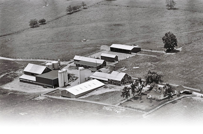
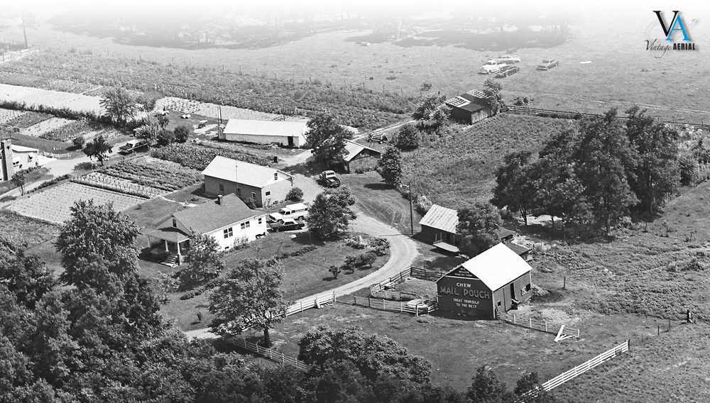
West Virginia has a total of 3.7 million acres of farmland, consisting of around 23,000 farms averaging in size of about 157 acres. West Virginia’s Agriculture industry has an economic impact of $806 million dollars per year. Hay, grown to feed the state’s livestock, is the #1 crop, providing 2% of West Virginia’s total agricultural receipts. Broilers (young chickens) are the state’s #1 agricultural commodity, generating about 31% of West Virginia’s total agricultural receipts. Other major crops of West Virginia are apples, peaches, soybeans, and tobacco. Our collection has aerial photos of many of these farms dating back to 1973!

We invite you to come and take a look at these homes and farms in our nearly 385,000 aerial photos of this great state. Home is the place where you became you. Find your way back!

Maryland: America In Miniature

Posted on 05/25/2018 by Nathan Lewis in New Content Releases

Fort Frederick State Park Annapolis MD, This fort served as Maryland’s frontier defense during the French and Indian War.

Today, we are excited to announce that nearly 250,000 aerial photos of Maryland are now available to search and view online. Maryland is often referred to as “Little America” and a great deal of our early history as a nation took place right here. In 1696 the King Williams School opened which was the first school in the United States. During revolutionary times Rockville was known as “Hungerford’s Tavern” the name of its most familiar landmark. One of the first calls to freedom from British rule was heard at the tavern in 1774. Maryland is one of two states which gave up some of its lands to help build the nation’s capital of Washington, D.C in 1790. Throughout the years there were a plethora of stories that directly contributed to forging a nation free from British rule. This is one of my favorites, On the morning of August 10th, 1813 residents of Saint Michaels having been forewarned of a British attack, hoisted lanterns to the masts of ships and in the tops of the trees. The height of light caused cannons to overshoot the town. This first known “blackout” was effective and only one house was struck and is now known as the “Cannonball House.” One year later America’s national anthem was written by Francis Scott Key. It is believed Key wrote the anthem on September 14th, 1814 while watching the bombardment of Fort McHenry in Baltimore Harbor.

Maryland’s little-known nickname, “America in Miniature” comes from its agriculture being as diverse as that of the nation itself. As the state has grown in population, traditional dairy, grain, and livestock production, while still active, have given way to products more directly related to consumers. Poultry, nursery and turf production, seafood, dairy, corn, soybeans, racing and pleasure horse industries now dominate Maryland agriculture. 40% of its land is in agriculture covering over 2 million acres. This area is split into nearly 13,000 farms averaging about 160 acres each. Approximately 350,000 people, including nearly 6,000 full-time farmers, are employed in some aspect of agriculture, making it the largest commercial industry in Maryland. This agricultural industry contributes more than $17 billion in revenue annually. Many of these farms, home, and businesses that have contributed so much to Marylands economy and culture have been preserved in our collection.

We invite you to come and take a look at these homes and farms in our nearly 250,000 aerial photos of this great state. Home is the place where you became you. Find your way back!

Virginia: The Old Dominion

Posted on 04/06/2018 by Nathan Lewis in New Content Releases

The 1987 classic film “Dirty Dancing” was filmed almost entirely at the Mountain Lake Lodge in Pembroke, Virginia

Today, we are excited to announce that over 745,000 aerial photos of Virginia are now available to search and view online. Virginia is known as “the birthplace of a nation” nicknamed “Old Dominion”. It was named for England’s “Virgin Queen,” Elizabeth I. Virginia was the 10th state added to the union and has a long history. Contrary to the common story of the famous dinner with the pilgrims, the first Thanksgiving actually took place here in 1619. With ocean access and a centralized location, almost dividing north from south, Virginia has seen the worst of the wars in our country. Patrick Henry made his “Give me Liberty or Give me Death” speech in St. John’s Church in Richmond. Eight years later The American Revolution ended with the surrender of Cornwallis in Yorktown. During the Civil war, Virginia was the site of more Civil War battles than any other state, with more than 120 major battles being fought here. That’s an average of one major battle every 12 days. Today Virginia is the “Internet Capital” with estimates that 50 to 70 percent of all Internet traffic flows through data centers located in Northern Virginia. In fact, the images you see at Vintage Aerial are served from Virginia within Amazon’s data centers there.

Jamestown, the first of the original 13 Colonies was founded for the purpose of silk cultivation. After blight fungus destroyed the mulberry trees sericulturist planted tobacco as a cash crop. Today agriculture is Virginia’s largest industry by far! The industry has an economic impact of $55 billion annually. This agricultural production is one of the most diverse in the nation. Many of Virginia’s commodities and products rank in the top 10 among all U.S. states. These include tobacco, apples, grapes, peanuts, tomatoes, and cotton. Virginia has 44,800 farms with an average size of 181 acres. Farms cover 8.1 million acres about 32 percent of Virginia’s total land area. Amazingly, Nearly 90 percent of Virginia farms are owned and operated by individuals or families. 17% of these primary farm operators are female. With this long history of family-run farms, we hope to have preserved this history and the memories attached to them in our collection.

We invite you to come and take a look these homes and farms in our over 745,000 aerial photos of this great state. Home is the place where you became you. Find your way back today!

Tennessee: The Meeting Place

Posted on 01/12/2018 by Nathan Lewis in New Content Releases

Fort Loudoun, Built by the British in 1756 during the French and Indian War

Today, we are excited to announce that over 323,000 aerial photos of Tennessee are now available to search and view online. The name “Tennessee” originated from the old Yuchi Indian word, “Tana-see,” meaning “The Meeting Place.” Tennessee is nicknamed “The Volunteer State” which it won during the War of 1812 when volunteer soldiers from Tennessee displayed great valor in the Battle of New Orleans. There is a very old and rich history here, far too much to cover in this short blog. The city of Bristol is known as the birthplace of Country Music and if you listen to Country then you know Nashville. Nashville’s Grand Ole Opry is the longest continuously running live radio program in the world. It has broadcast every Friday and Saturday night since 1925. Nashville is home to 341 recording studios and nearly 40 percent of the entire music industry is concentrated in Los Angeles, New York, and Nashville. The music made in Nashville contributes a whopping $9.7 billion within the Nashville metropolitan area.

Another major stop in Tennessee is the city of Memphis. Elvis Presley’s home called Graceland is located here and is the second most visited house in the country. Every year I take a short road trip and the last two years were Nashville and Memphis. In Memphis, we enjoyed the nightlife on Beale Street and ate some of the best BBQ I have ever had at Central BBQ. We took the Gibson Guitar Factory tour where they still hand make each guitar just as they did when they first started, this was an amazing experience.

While most commonly known for its music and history Tennessee has a strong backbone in agriculture. Tennessee farming is far from the mule-and-plow stereotype of the past. By keeping up with the technological times and embracing sustainability, agriculture and forestry have remained vital sectors in the Volunteer State, contributing $74.8 billion to Tennessee’s economy each year. Leading agricultural commodities are cattle and calves, broilers and milk, and also soybeans, corn, hay, wheat, cotton, and tobacco. With just over 67,300 farms spread across 9 million acres of land Tennessee contains many prosperous traditional farming operations. More than 349,000 Tennesseans are employed in both the agricultural and forestry industries. We invite you to come and take a look these homes and farms in our over 323,000 aerial photos of this great state. Home is the place where you became you. Find your way back today!

North Carolina: The Old North State

Posted on 10/06/2017 by Nathan Lewis in New Content Releases

Wright Brothers National Memorial at Kitty Hawk

Today, we are very thrilled to announce that over 900,000 aerial photos of North Carolina are now available to search and view online. North Carolina is the 29th largest state with 48,718 square miles of land. There are 1,500 lakes of 10 acres or more and 37,000 miles of freshwater streams. Roughly 8.1 million people live in the Tar Heel State. Tar Heel? You might be asking what is a Tar Heel and how is that the UNC mascot? The origin of this nickname is mysterious, it supposedly came from the days when NC produced a lot of tar, and someone saw a set of footprints made by someone who had stepped in the tar. North Caroline has a very old and rich history, my personal experience with this was a family trip to the Biltmore Estate when I was young. The Biltmore Estate in Ashville is America’s largest home and includes a 255-room chateau, an award-winning winery, and extensive gardens. I did not get to enjoy the wine but I did love the underground indoor bowling alley.

I feel I am not doing The Old North State justice without at least some key points form it’s very significant American history. The first English colony in America was located on Roanoke Island. Walter Raleigh founded it. The colony mysteriously vanished with no trace except for the word “Croatoan” scrawled on a nearby tree. Many people believe that North Carolina was the first state to declare independence from England with the Mecklenburg Declaration of 1775. North Carolina is the 12th state to ratify the United States Constitution on, Nov. 21st, 1789. In 1903 the Wright Brothers made the first successful powered flight by man at Kill Devil Hill near Kitty Hawk. The Wright Memorial at Kitty Hawks now commemorates their achievement. This is also how the state claimed its slogan “First in Flight”. Finally, Babe Ruth hit his first home run in Fayetteville on March 7, 1914.

North Carolina is one of the most diversified agriculture states in the nation. The state’s 50,200 farmers grow over 80 different commodities, utilizing 8.4 million of the state’s 31 million acres. The average farm size is 168 acres and North Carolina leads the nation in furniture, tobacco, sweet potato, brick, and textile production. The state ranks seventh nationally in farm profits with a net farm income of over $2.8 billion. With over 900,000 photos of these rural farms, we hope to preserve and share this history with you. Hopefully, you will find a piece of your history here too.

New York: The Untold Story

Posted on 07/07/2017 by Nathan Lewis in New Content Releases

Family farm in Cortland County, just north of Pitcher NY

Today, we are excited to announce that over 400,000 aerial photos of New York are now available to view online. When I think of New York mainly what comes to mind is all the sights and attractions of New York City itself. The City of New York is one of the main cultural centers of the world with a little over 8 million people speaking over 800 languages. It has the Empire State Building, The Statue of Liberty, Wall Street, and Central Park just to name a few of the many attractions. All that the City of New York has to offer is just a small part, roughly 0.6% of the total area of New York. The real story and what keeps New York alive is its agriculture.

New York is a leading agricultural state, worth $6.36 billion in 2015. It is ranked number one in the production of Yogurt, Cottage Cheese, and Sour Cream as well as number two in Apples, Maple Syrup, and Pumpkins. Dairying is New York’s most important farming activity with over 18,000 cattle farms. Milk sales account for 50% of the total agricultural receipts. The oldest cattle ranch in the US was started in 1747 at Montauk on Long Island. About 23% of New York State’s land area, or 7 million acres, is farmland. This Industry has nearly 36,000 family farms producing some of the world’s best food. With over 400,000 images now available we hope to share this untold story of New York through our images and your stories connected to them. We hope you come take a look and experience New York’s rich rural history.

Missouri: "Show Me" From Above

Posted on 05/08/2017 by Nathan Lewis in New Content Releases

Fort Osage an early 19th century factory trading post, 1990

Today, we’re excited to announce that 519,989 aerial photos of Missouri are now available to view online. The vast majority of these images depict the importance of small family farms in Missouri’s rich history. We hope that you’ll find some family history in these photos and share them with others.

The state of Missouri was named after a tribe of Sioux Indians that lived in the state called the Missouris. The word “Missouri” means “wooden canoe people”. Missouri is known as the “Show Me State” which is an expression that may have began in 1899 when Congressman Willard Duncan Vandiver said, “I’m from Missouri and you’ve got to show me.”

Missouri has a rich history and is home to many landmarks and important historic events. The Gateway Arch in St. Louis is the tallest man-made national monument in the United States. It is 630 feet wide and stands 630 feet tall. The Anheuser-Busch brewery in St. Louis is the largest beer producing plant in the United States. This brewery produces Budweiser, which is the best selling beer brand in the world. St. Louis was also the host of the first Olympic Games ever held in the United States. At the St. Louis World’s Fair in 1904, the ice cream cone was invented. An ice cream vendor ran out of cups and asked a waffle vendor to help by rolling up waffles to hold ice cream. This fair also introduced some other favorite sweets such as cotton candy, iced tea, and Dr. Pepper.

While Missouri has a rich history for many things, none is more important than its farming industry which has been at the heart of many Missouri families. The Show Me State is home to more than 100,000 farms, covering two-thirds of the state’s land acreage, which comes to nearly 30 million acres. On average, Missouri farms are about 269 acres and nearly all are family owned and operated. Soybeans are the most produced food commodity in Missouri followed by corn and cattle. The soybean industry generates $4.3 billion dollars for Missouri and all the farming combined generates over $10 billion dollars.

Minnesota: Big Names, Big Things, Big Farms

Posted on 03/21/2017 by Nathan Lewis in New Content Releases

Jolly Green Giant, 1980

Minnesota is known as the “Land of 10,000 Lakes” but it actually has 11,842 Lakes! Perhaps “10,000” just rolls off the tongue a bit better! These lakes make up 90,000 miles of shoreline, which is more than California, Florida and Hawaii combined. This is just the beginning of “big” in Minnesota.

Big Names

The Legendary poet, songwriter, and musical genius Bob Dylan was born in Duluth, Minnesota in 1941. Bob Dylan has sold well over 40 million albums and he is also one of my personal favorites. Next up, Before he was Prince, The Artist Formerly Known as Prince, and then Prince again, singer/songwriter and music legend Prince Rogers Nelson was born in Minneapolis on June 7, 1958. He has sold over 100 million records worldwide, making him one of the best-selling artists of all time.

Big Things

You may not know this, but Minnesota is home to some of the largest “things” in the world. The Mall of America in Bloomington is the size of 78 football fields – 9.5 million square feet. This is the second largest mall in America. The world’s largest ball of twine built by a single person sits in Darwin, weighing in at 17,400 pounds and twelve feet in diameter. The world’s largest pelican, Pelican Pete is a concrete statue that stands 15.5 feet tall at the base of the Mill Pond dam in downtown Pelican Rapids. The world’s largest “kneeling statue,” Paul Bunyan Statue is in Akeley and stands 20 feet tall. The brand “Green Giant Great Big Tender Peas” was created in 1925 and company mascot Jolly Green Giant was born. He stands tall and green in Blue Earth at 55.5 feet tall.

Big Farms

Minnesota is the 5th ranked state for agricultural production. The annual economic activity generated in Minnesota related to agriculture is more than 75 billion dollars. There are 26 million acres of farmland in Minnesota totalling 74,542 farms. The average farm size is 349 acres and they produce corn, soybeans, hogs, dairy products and cattle predominantly. Our photos at Vintage Aerial depict many of these rural homes and farms, and we are happy to announce that we have just made 442,000 photos in Minnesota available. You can search these photos by a current address or by a map location. We hope you enjoy!

Kentucky: Bourbon Country

Posted on 01/10/2017 by Nathan Lewis in New Content Releases

Maker's Mark Distillery, 1979

From horse racing and Bourbon Country, to the culture of Appalachia, Civil War significance and Abraham Lincoln, Kentucky is a state with deep traditions and important history. Kentucky has had a strong agricultural community with nearly 85,000 farms in 2011, that averaged 164 acres. Horses were the leading source of farm income for Kentucky farmers. Kentucky is home to some of the world’s leading thoroughbred farms and thoroughbred auctions. Kentucky still leads the nation in burley tobacco production and beef cattle east of the Mississippi River. Located in the south central United States along the west side of the Appalachian Mountains, Kentucky ranks 37th in land size, with 39,732 square miles.

Today we are excited to be releasing 385,000 aerial photos from Kentucky. Nearly all these photos are searchable by address or by map location. It has been an interesting journey viewing the many types of farm photos as the geocoding process took shape. Hopefully there are many memories and stories waiting to be shared and cherished within these amazing images.

More Ohio Counties Released

Posted on 04/07/2015 by Lance Roper in New Content Releases

We’re releasing 400,000 more images from our collection in Ohio!

Ohio is our home state, and we’re on track to open all images in the state by this summer! We’ll keep updating our blog with a list of recent openings for your convenience.

Help us spread the word to people who have roots and connections in these areas. We’re looking for volunteers to help us identify photos and leave stories.