

Join Our Community
33,627 members are helping us to bring our collection to life.
Create a free Vintage Aerial account now to start commenting on photos, pinning locations, and earning points redeemable for our products!
Sign up now and receive a coupon for 10% off your first order!
Comments
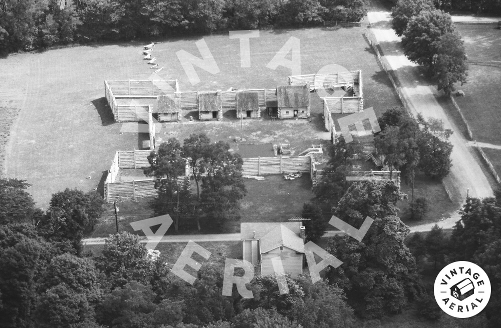
This is Fort Roberdeau Historic Site (also known as The Lead Mine Fort) at 383 Fort Roberdeau Rd, Altoona, Pennsylvania. It was built in 1778, during the American Revolution and was occupied until 1780. Initial efforts were made in 1939-1941 to reconstruct the fort by concerned local agencies with support from the National Youth Administration. The stockade was finally reconstructed as a Bicentennial project in 1975-1976. The original fort was built of horizontal logs with a bastion at each corner. The fort was originally erected by Gen. Daniel Roberdeau to protect local lead mining activities from the Native Americans and Tories. The site consists of the reconstructed fort and its structures (officers' quarters, storehouse, barracks, blacksmith shop, lead miner's cabin, powder magazine, and lead smelter), a restored barn (built in 1859) which serves as visitor center, a restored farmhouse (built c. 1860), a sinkhole, a trail system, and a log house (built in 2012) built in the style of an original frontier house. In July 2018, the Mt. Lion Observatory was opened on the grounds of the Fort, a joint venture between the Fort Roberdeau Association and Neil Armstrong Planetarium at Altoona Area High School. The fort is open to the public as a historic site, administered and owned by Blair County. Looking west. The fort can also be seen in: 1980 Film Roll 45 Photo 45-PBL-1 (1980 Blair County, PA), 1980 Film Roll 45 Photo 45-PBL-4 (1980 Blair County, PA), 1993 Film Roll 107 Photo 107-PBL-21 (1993 Blair County, PA).